About Rustic Roads

There are 117 designated Rustic Roads spanning more than 669 miles through 59 counties.
Download the Rustic Road Guide.
We encourage people to explore Wisconsin Rustic Roads, no matter what the season.
The Wisconsin Legislature established the Rustic Roads program in 1973 to help citizens and local units of government preserve what remains of Wisconsin’s scenic, lightly traveled country roads.
Unique brown and yellow signs mark the routes of all officially designated Rustic Roads. These routes provide bikers, hikers, and motorists an opportunity to leisurely travel through some of Wisconsin’s scenic countryside.
A small placard beneath the Rustic Roads sign identifies each
Rustic Road by its numerical designation within the total statewide system. Each Rustic Road is identified by a 1- to 3-digit number assigned by the Rustic Roads Board. To avoid confusion with the State Trunk Highway numbering, a letter “R” prefix is used such as R-50 or R-120.

WisDOT pays the cost of furnishing and installing Rustic Roads marking signs. An officially designated Rustic Road shall continue to be under local control. The county, city, village, or town shall have the same authority over the Rustic Road as it possesses over other highways under its jurisdiction.
A Rustic Road is eligible for state aid just as any other public highway.
What is a Rustic Road?
To qualify for the Rustic Road program, a road
• Should have outstanding natural features along its borders such as rugged terrain, native vegetation, and native wildlife, or include open areas with agricultural vistas which singly or in combination uniquely set this road apart from other roads.
• Should be a lightly traveled local access road, one which serves the adjacent property owners and those wishing to travel by auto, bicycle, or hiking for purposes of recreational enjoyment of its rustic features.
• Should be one not scheduled nor anticipated for major improvements that would change its rustic characteristics.
• Should have, preferably, a minimum length of 2 miles and, where feasible, should provide a completed closure or loop, or connect to major highways at both ends of the route.
• A Rustic Road may be dirt, gravel or paved road. It may be one-way or two-way. It may also have bicycle or hiking paths adjacent to or incorporated in the roadway area.
• The maximum speed limit on a Rustic Road has been established by law at 45 mph. A speed limit as low as 30 mph may be established by the local governing authority.


R-28 | Wisconsin Rustic Road 28
Northwest Wisconsin: Polk County
Mains Crossing (old Highway 8), beginning at the intersection of County H then extending east to County D.
Map: R-28 Online Map
Length: 5.2 miles
Surface: Paved and gravel portions
Passing Apple River County Park and crossing the scenic Apple River, R-28 is characterized by pleasant views of deciduous forests and open farmland. Located along the route are three small churches, two cemeteries and the Apple River Town Hall.
R-41 | Wisconsin Rustic Road 41
Northwest Wisconsin: Polk County
Clara Lake Drive and 70th Street between County E and County G.
Map: R-41 Online Map
Length: 2.3 miles
Surface: Paved and gravel portions
This road wanders past scenic woodlands and farmlands. Clara Lake Drive passes the Hunky Dory Farms Resort, built in 1902 and still in operation. A canopy of trees shade the gravel portion of this beautiful road.


R-67 | Wisconsin Rustic Road 67
Northwest Wisconsin: Barron and Polk counties.
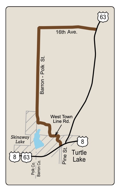
Portions of Pine Street, West Town Line Road, Barron-Polk Street and 16th Avenue, forming a loop from US 8 to US 63.
Map: R-67 Online Map
Length: 4.6 miles
Surface: Paved and gravel portions
R-67 winds through woods and wetlands, along fields and forests, and around the edge of Skinaway Lake. Wildlife and wildflowers abound. This route provides a quiet, picturesque adventure through the northwestern Wisconsin countryside.
R-93 | Wisconsin Rustic Road 93
Northwest Wisconsin: Polk County
Chippewa Trail from 145th Street to County GG.
Map: R-93 Online Map
Length: 2.8 miles
Surface: Gravel
R-93 is a beautiful country road that meanders through a wooded area in northwest Wisconsin in the town of Luck. A tree canopy covers mostof this road. Chippewa Trail also curves around many ponds and wetland areas.
Hikers, bikers and motorists in this area can see wildlife such as turkey and opossum. Local lore is that the Chippewa Indians used this route in pre-settlement times as they traveled between Butternut and Bone lakes.
Note: It is recommended that travelers unfamiliar with the area access R-93 at County GG.


R-101 | Wisconsin Rustic Road 101
Northwest Wisconsin: Polk counties.
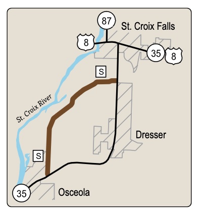
County S forming a loop off WIS 35 between Osceola and St. Croix Falls.
Map: R-101 Online Map
Length: 4.3 miles
Surface: Paved
R-101 features oak, cedar and pine trees, a trout stream, rock outcroppings and a variety of wildlife as it parallels the St. Croix River. Trail heads are adjacent to the road. The traveler will also pass by the St. Croix National Scenic Riverway ranger station and maintenance facility.
R-103 | Wisconsin Rustic Road 103
Northwest Wisconsin: St. Croix and Polk Counties
Portions of 230th Avenue, Marine Road, County Line Avenue and Polk/St. Croix Road through the town of Somerset in St. Croix County and the town of Farmington in Polk County.
Map: R-103 Online Map
Length: 2.8 miles
Surface: Paved and gravel portions
This route leads to the historic Somerset Landing—a river access point in the St. Croix National Scenic Riverway that features a boat launch and other amenities.
R-103 features sandstone bluff outcroppings, tree canopies, prairie and farm views. A snowmobile route crosses Polk/St. Croix Road and a marked bike route connects to R-103 at 40th Street.

